NASA "saucer" test at PMRF

SUBHEAD: Vehicle with giant 'puffer fish' parachute takes flight in $150m experiment over Hawaii.

By AP Staff on 29 June 2014 in The Guardian -
(http://www.theguardian.com/science/2014/jun/28/nasa-launch-saucer-vehicle-parachute-hawaii-mars)


Image above: Artists rendering of NASA's Low-Density Supersonic Decelerator after takeoff. From (http://www.nbcnews.com/science/space/look-out-mars-nasa-gets-its-flying-saucer-ready-launch-n120741).

[IB Publisher note: Kicking of the season of RIMPAC is a "flying saucer" experiment for landing men on Mars. Maybe before invading another planet we should figure out how to live on the one we're designed for. That certainly won't flow from the kind of activity the US Navy coordinates during RIMPAC.]

A saucer-shaped Nasa vehicle launched by balloon high into Earth's atmosphere splashed down in the Pacific Ocean on Saturday, completing a successful test of technology that could be used to land on Mars.

Since the twin Viking spacecraft landed on the red planet in 1976, Nasa has relied on the same parachute design to slow landers and rovers after piercing through the thin Martian atmosphere.

The $150m experimental flight tested a novel vehicle and a giant parachute designed to deliver heavier spacecraft and eventually astronauts.


Despite small problems such as the giant parachute not deploying fully, Nasa deemed the mission a success. "What we just saw was a really good test," said Nasa engineer Dan Coatta with the Jet Propulsion Laboratory in Pasadena, California.

Viewers around the world with an internet connection followed portions of the mission in real time thanks to cameras on board the vehicle that beamed back low-resolution footage. After taking off at 11.40 am from the Pacific Missile Range Facility on the Hawaiian island of Kauai, the balloon boosted the disc-shaped vehicle over the Pacific. Its rocket motor then ignited, carrying the vehicle to 34 miles (55km) high at supersonic speeds.

 
The environment at that altitude is similar to the thin Martian atmosphere. As the vehicle prepared to drop back the Earth, a tube around it expanded like a Hawaiian puffer fish, creating atmospheric drag to dramatically slow it down from Mach 4, or four times the speed of sound.

Then the parachute unfurled and guided the vehicle to an ocean splashdown about three hours later. At 110 feet (33 meters) in diameter, the parachute is twice as big as the one that carried the one-tonne Curiosity rover through the Martian atmosphere in 2011.


The test was postponed six times because of high winds. Winds need to be calm so that the balloon does not stray into no-fly zones.


Engineers planned to analyze the data and conduct several more flights next year before deciding whether to fly the vehicle and parachute on a future Mars mission.

"We want to test them here where it's cheaper before we send it to Mars to make sure that it's going to work there," project manager Mark Adler of the Nasa Jet Propulsion Laboratory said during a pre-launch news conference in Kauai in early June.

The technology envelope needs to be pushed or else humanity won't be able to fly beyond the International Space Station in low-Earth orbit, said Michael Gazarik, head of space technology at NASA headquarters.

Technology development :is the surest path to Mars", Gazarik said at the briefing.

.

Yosemite Park Turns 150

SUBHEAD: Now some park regions will be once again be accessible only by foot, to protect delicate regions of the park.

By Sasha Khokha on 28 June 2014 for NPR News -
(http://www.npr.org/2014/06/28/326216331/as-yosemite-park-turns-150-charms-and-challenges-endure)


Image above: Yosemite is located in east central California. The park covers an area of 761,268 acres  and reaches across the western slopes of the Sierra Nevada mountain chain. From (http://wordlesstech.com/2012/03/10/boulders-yosemite-national-park/).


Yosemite National Park, in California's Sierra Nevada, is celebrating the 150th anniversary of the law that preserved it — and planted the seeds for the National Park system. At the same time, the park faces the challenge of protecting the natural wonders from their own popularity.

Since President Abraham Lincoln signed the 1864 law that protected this land, visitors have been enjoying the park's spectacular features, from Half Dome to the giant sequoia grove — and the moonbow at Yosemite Falls.

The moonbow is like a rainbow, but at night. Some photographers time their visits to the park so they can catch a glimpse of this rare phenomenon, which is only visible when the moonlight catches the mist at the waterfall.

Four million people visit the park each year. Photographer Mark Zborowski, who's here to capture the moonbow, is among them.

He explains that the naked eye just sees a thin silvery band, but a long exposure with a camera can capture the moonbow's color. The entire scene is "just a spectacular view," Zborowski says.

"You look up, and you can see the ridges up high, and the stars," he says. "It fills your eyes — gives you a lot to feed off of."

Photography has been key to Yosemite's allure. Historians think it may have helped convince Lincoln to preserve a place he'd never visited.

Today you can still see some of the sites that appealed to those early photographers. Ranger and park historian Dean Shenk points out one of Yosemite's most famous trees, The Grizzly Giant — which he says is close in size to the Leaning Tower of Pisa.

"The first photographer who came to the Mariposa Grove in 1859 took a picture of the Grizzly Giant from the angle that we're looking at today," Shenk says.

This grove of giant sequoias, together with Yosemite's iconic valley, became the first federally protected wilderness areas on June 30, 1864, when Lincoln signed the Yosemite Land Grant.
"In the midst of our country's civil war, with all the bloodshed, all the battle, all the anxiety," Shenk says, "many of us would like to think that he took a moment and perhaps shook his head, or smiled, in just perhaps a sigh of pleasure."

Shenk compares the idea of protecting these lands to the seed of a giant sequoia, which is as tiny as an oat flake. "That seed planted by Lincoln's signature has expanded to the National Park System throughout America," he says.

But even those who urged Congress and Lincoln to preserve Yosemite warned that tourism had to be managed carefully, Shenk says. That includes Frederick Law Olmsted, the landscape architect who helped design New York's Central Park and helped oversee the Yosemite land grant.

"Not only did he predict the millions of people in the future, but he also said ... 'We must be aware of the capricious damage that one visitor might make, and then multiply it by the millions,'" Shenk says.


Olmstead and Yosemite

SUBHEAD: The vision of America's first and greatest landscape architect for wilderness preservation.

By Dan Anderson in 1998 for Yosemte -
(http://www.yosemite.ca.us/library/olmsted


Image above: Waterfall in Yosemite National park. From (http://www.wondermondo.com/Attractions/Waterfalls.htm).

[IB Publisher's note: Frederick Law Olmstead came to prominence with his winning design for New York's Central Park in 1853. Olmstead went on to reinvent landscape architecture - transforming it from a special service for rich landowners to the enhancements and preservation of the public commons. He designed many of the 19th century major urban parks including Brooklyn, Boston and Buffalo, Detroit, Denver, Milwaukee and many more. He also did the campus master plan for Stanford University the University of California Berkeley. His greatestwork may have been the philosophy he developed in the formulation of Yosemite Park and later the establishment of the Nation park System with the design of Yellowston National Park. For more see (http://en.wikipedia.org/wiki/Frederick_Law_Olmsted)] 

Yosemite Preliminary Report
Written in 1865 by landscape architect Frederick Law Olmsted when he served briefly as one of the first Commissioners appointed to manage the grant of the Yosemite Valley and the Mariposa Big Tree Grove from Congress to the State of California as a park, this Report offers one of the first systematic expositions in the history of the Western world of the importance of contact with wilderness for human well-being, the effect of beautiful scenery on human perception, and the moral responsibility of democratic governments to preserve regions of extraordinary natural beauty for the benefit of the whole people.

The Report also includes characteristically thoughtful suggestions for managing the Park for human access with minimal harm to the natural environment.

Olmsted read the Report to his fellow Commissioners at a meeting in the Yosemite Valley on August 9, 1865; ultimately intended for presentation to the state legislature, it met with indifference or hostility from other members of the Commission, and was quietly suppressed.

Olmsted himself left California for good at the end of 1865; he had arrived there just a little more than two years before to assume responsibilities as Superintendent for the Mariposa Mining Estate. Only in the twentieth century has his Preliminary Report come to be widely recognized as one of the most profound and original philosophical statements to emerge from the American conservation movement.

.

Kauai's PMRF is bang out of sight

SUBHEAD: The PMRF on Kauai and what the increasing military presence in the Pacific means for Hawaii and the world.

By Jon Letman on 26 June 2014 for Hawaii Independent -
(http://hawaiiindependent.net/story/pmrf-kauais-biggest-bang-is-out-of-sight)


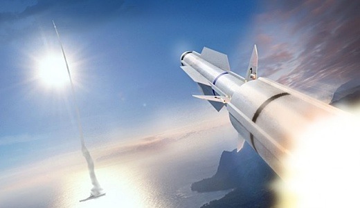
Image above: The Navy announced on 5/21/14 the first live-fire test of Raytheon's SM-3 landbased missile from the PMRF. It is a variation of Lockheed Martin’s Aegis missile defense system. From (http://www.inquisitr.com/1262375/with-successful-test-firing-of-sm-3-missile-us-inches-closer-to-advanced-defense-against-ballistic-missiles-attacks/).

When you think of Kauai perhaps you envision lush tropical foliage, hiking in Waimea Canyon or kayaking the Wailua River.

What you probably don’t think of are Advanced Hypersonic Weapons, Ballistic Missile Defense testing, Predator drones, low-earth orbit intercepts and sophisticated tracking systems that monitor activities around the globe.

Whale watching tourists sailing along Kauai’s famed Nā Pali Coast have no idea they are sharing the scenic waters with defense contractors Boeing, Raytheon, Lockheed Martin, Northrop Grumman and General Atomics, among others.

But just as Kauai is a major center for biotech companies (Syngenta, Dupont-Pioneer, Dow-AgroSciences, BASF), so is it a critical, albeit under-reported, testing and training hub for the U.S. military, the Defense Advanced Research Projects Agency (DARPA), NASA, the Missile Defense Agency (MDA) and Sandia National Laboratories which all conduct programs at the Pacific Missile Range Facility (PMRF).

Unlike Oahu, Kauai’s military presence goes largely unseen. Yet PMRF, which has nearly 75-year-old roots as an Army landing site, occupies a seven and a half by three-quarter’s mile wide swath of coast at Barking Sands on the edge of the Mānā Plain. This once marshy wetland, long ago drained to grow sugar cane, is today home to GMO crop fields that form a buffer around PMRF.

For most tourists and even many Kauai residents, PMRF remains terra incognita. Although PMRF is covered in the local Garden Island newspaper and the Honolulu Star-Advertiser, it’s rarely mentioned in national or international media unless there’s a major launch like the May 22 Aegis Ashore ballistic missile defense (BMD) test.

Recently, I had the chance to spend a few hours touring PMRF with its commanding officer Captain Bruce Hay as my guide. As part of its community outreach, PMRF’s public affairs officer invited me (along with two other local reporters) to see what goes on largely out of view and without scrutiny.

Going ‘Open kimono’
After a cafeteria-style lunch at PMRF’s Shenanigans café during which Capt. Hay promised our tour would be “open kimono,” we were led to his car—a Chevy Malibu as blinding white as his uniform. We piled in and were taken on a short drive to a 135-foot long rocket launch rail that resembled a grey steel bridge jutting out over the sand.

The captain described how the launch was designed to fire the Space-borne Payload Assist Rocket, also called Super Strypi—a collaborative project of Sandia National Laboratories, Aerojet Rocketdyne Corp., the University of Hawaii and PMRF. The main function of its first mission will be to demonstrate how to inexpensively deliver a 300-kilogram payload into low-earth orbit.

For the project’s partners, Super Strypi represents not only a technical achievement but an educational opportunity as private and public sectors push to advance Hawaii’s position in the world of the aerospace and defense industries.

Launching a rocket—any kind of a rocket—at PMRF is for Hay “pretty neat.” Over the course of the two and a half hour tour, he repeatedly expressed his enthusiasm for involving children in launches (as observers), whenever possible. It’s all part of PMRF’s—and more broadly, the aerospace and military defense industry’s—enthusiasm for supporting STEM (Science, Technology, Engineering and Math) education.
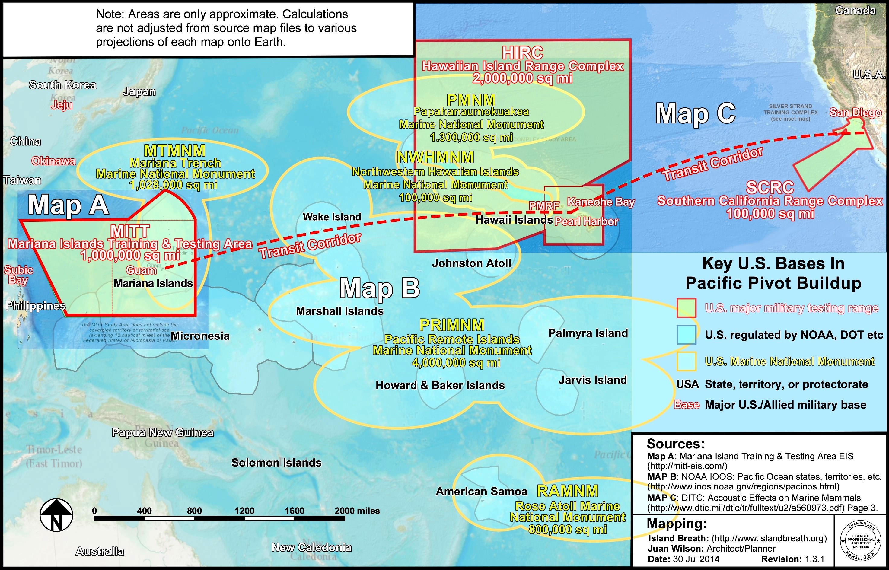
Not just Kauai
Contrary to popular belief, PMRF is not limited to Kauai’s Mānā Plain. The range also includes “small installation” sites at Kokee State Park, Mākaha Ridge, Kamokala Ridge, Port Allen, Mauna Kapu on Oahu, Pōhakuloa Training Area on Hawaii Island and the privately-owned island Niihau which is home to a “perch site” comprised of a helicopter pad, electronic warfare equipment and surveillance radar.

Less than two dozen miles south of Niihau is Kaula, a steep offshore islet inhabited by bird colonies. Like Kahoolawe island and Pagan island in the Northern Marianas, part of Kaula is being used for “intert air-to-surface weapons” testing. Unlike Kahoolawe and Pagan, however, there is effectively no protest or even knowledge that this island is being used.

As we drove from one site to the next, Hay pointed out that Kaula’s ownership is in question. “Is it the Federal Government? Is it the Department of Defense? Is it the State of Hawaii? I don’t know. I’m not a lawyer—thank God,” he quipped.

“We expect use to go up as all the forces that were in the desert for the last 20 years are starting to flow back to bases in the United States. Marines, Air Force and Army are all coming back,” he said then, without missing a beat, pointed out a playing field visited by pro football players last year.

One of PMRF’s greatest assets Hay has said previously, is the fact that it has a whole lot of nothing.

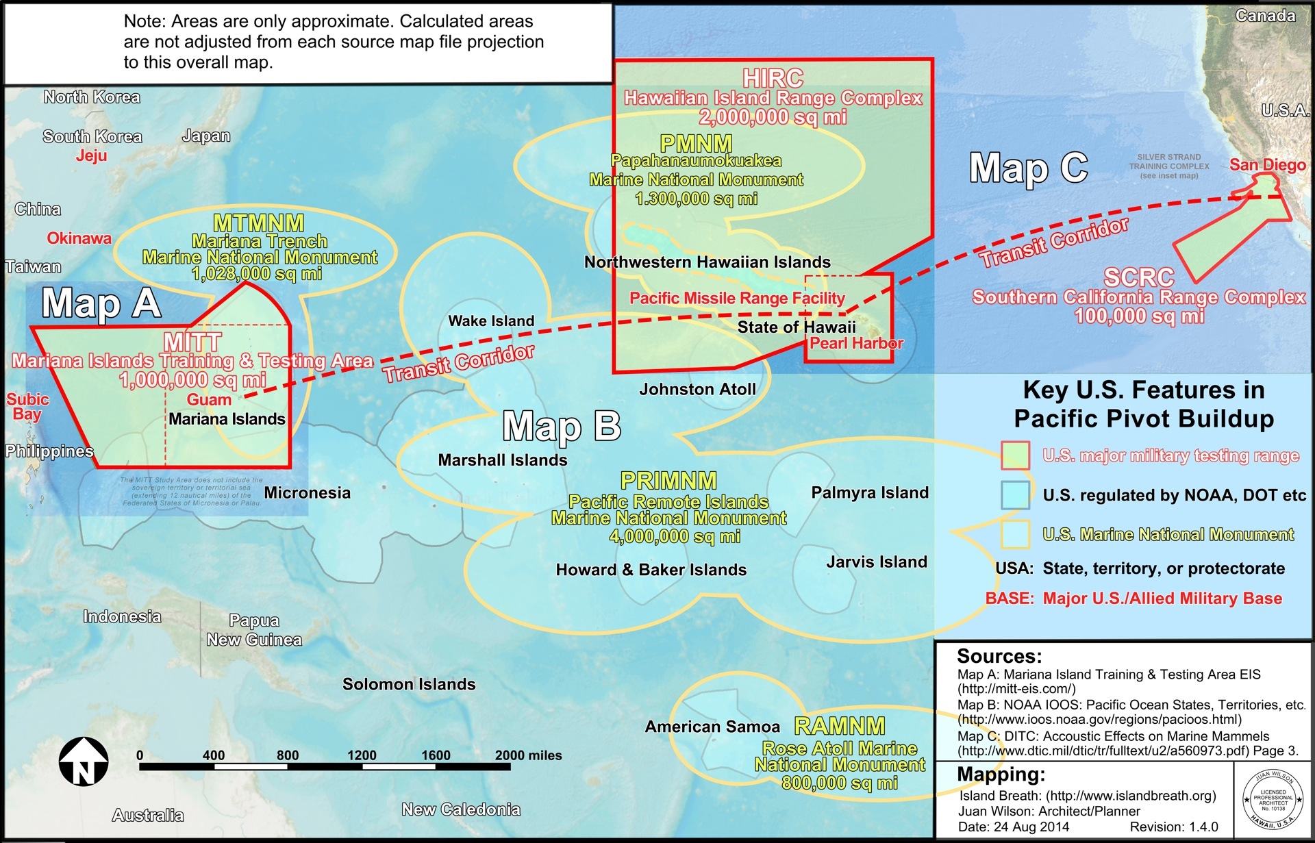
That “nothing” is, in fact, over 2.1 million square miles of “extended range” roughly the size of the continental United States west of the Mississippi including Baja, Mexico. This is in addition to 1,100 square miles of “instrumented sea range” and 42,000 square miles of “controlled airspace.”
From Hay’s perspective, conducting testing and training west of Kaua‘i means the military is not impacting shipping lanes or civilian air traffic. Critics, however, are increasingly challenging environmental impacts, particularly the use of high-frequency sonar and its alleged impact on marine life from deep water corals to large marine mammals.

Out in that vast watery “nothingness” PMRF operates MATSS (Mobile-At-Sea-Sensor system)—a barge loaded with antennae, telemetry tracking dishes and equipment used to support BMD testing. Hay noted that when the crew is waiting to support training exercises, there’s plenty of time to cast rods and “have some beautiful ahi sashimi.”

Base Living
PMRF touts itself as an important economic driver on Kaua‘i, proudly describing its role in employing local people. According to Hay, the base employs around one thousand (770 contractors, tenants and other service providers, 140 civilian and 87 military officers/enlisted). Currently about 150 people live on base in some 50 modest housing units.

Although PMRF has many of the amenities you’d find in a small town (gas station, car wash, barber shop, post office, an outdoor theater, Subway sandwich outlet, parks and recreational sports facilities), it doesn’t feel like your average civilian town. Maybe it was the Regulus cruise missile mounted on display, but the place just feels like a military base which, of course, it is.

Driving along PMRF’s almost carless roads, we slowed down to look at roadside tanks. Hay said the dummy tanks—called “composites”—are used for pilot training. The tanks aren’t fired at with live ammunition but they can provide a realistic training object particularly when equipped with heat generators that simulate a real “live” target.

“You know, we do all kinds of cool testing and training on base,” the captain said, “but I get more questions about these than anything else.” He was referring to the 26 seaside guest cabins (for retired and active duty military personnel) just two minutes walk from the longest continuous beach in the Hawaiian islands. If you know someone on base, he explained, “they can hook you up.”

‘The Roc’
Next we stopped at an unremarkable beige building which Hay identified as his primary working headquarters—the Range Operations Complex or “the Roc.” Hay led us to a Standard Missile Three (SM-3) displayed on a mount behind a plaque that reads “Ad Astra Per Aspera” (“To the stars through adversity”).

The SM-3 (manufactured by Raytheon which describes it as “the world’s only ballistic missile killer deployable on land or at sea”), Hay explained, is designed to “engage non-air-breathing ballistic missile targets.” In other words, the SM-3 is intended to be fired at an incoming enemy missile and destroyed mid-air by sheer kinetic force. It’s the “kill vehicle,” Hay explained, gesturing to the rocket’s 21-inch tip, that matters most.

“It’s pretty neat to think we are hitting a bullet with a bullet,” Hay said, referring to the 21-foot 6-inch long white priapic missile behind him.

Hay described ballistic missile defense as “very successful, in the low nineties” but a recent Los Angeles Times investigation found that the Boeing-manufactured $40 billion Ground-based Midcourse Defense system, tested at PMRF-partnering facility Vandenberg Air Force Base in California was “unreliable, even in scripted tests.” One physicist at Lawrence Livermore National Laboratory called the system’s test record “abysmal,” the Times reported.

Speaking about BMD testing at PMRF Hay said, “When we do a live engagement, we’re going to shoot towards Kauai, not at Kauai. That’s an important distinction.”

Aegis Ashore
Meanwhile, other ballistic missile defense systems are tested at PMRF, most notably Aegis Ashore.
PMRF has a long history of supporting missile defense testing. One of the most high-profile systems being tested today is Aegis Ashore. Essentially identical to the BMD system deployed on Aegis naval destroyers, Aegis Ashore is designed for use on land.

A product of Lockheed Martin, Raytheon, the U.S. Navy and the Missile Defense Agency, Aegis Ashore, was championed by the late Senator Daniel Inouye and is slated for deployment in Romania in 2015 and Poland in 2018.

As Capt. Hay pulled up in front of a dull, white building topped with radar antenna equipment behind a high black fence topped with barbed wire he said, “If you’re familiar with ships, it looks a lot like a Ticonderoga Class (guided missile) cruiser.” He explained that Aegis on a ship requires 300-400 people to operate. “Take a stab at how many sailors run this facility,” he said.
“Fifteen?” I guessed.

“Less, but not much. Twelve sailors and a few contractors,” he replied. According to Hay, Aegis Ashore is cheaper but still expensive. The building alone (Aegis Ashore Missile Defense Test Complex) cost $60 million. Once fitted with all radar and other equipment, that cost soared to $700 million. On a ship, Hay said, that would be around $2 billion even before crew salaries and fuel.
Aegis Ashore, he said, “gives you an opportunity to do that at much less cost.”

The first Aegis Ashore test took place at PMRF just three days before my visit and made news for the mysterious vapor trails it left behind, but the real news no one seems to talk about in Hawaii is how Kauai is at the center of a BMD system which the Obama administration insists is to protect Europe from Iran but whose deployment has been repeatedly and angrily criticized by Russia.

Now, with the backdrop of increased tensions between the U.S., NATO and Russia resulting from Moscow’s annexation of Crimea and fighting in Ukraine, far-off Kauai’s own role in global military conflicts is underscored.

When I asked Capt. Hay who Aegis Ashore is intended to defend against he declined to name names, instead saying, “Think of all the antagonists all throughout Europe and the Middle East.”

Asked how the schedule deployment was being received Hay said, “The former Soviet Union wasn’t too crazy about it, for obvious reasons. But by and large it’s been a non-issue.” I did not ask how the U.S. would respond to a Russian BMD deployment in Mexico, Canada, or Cuba.

Big things for important people
Kauai’s Garden Island newspaper recently reported that PMRF is pushing forward a proposal to be renamed as the Inouye Pacific Range Facility in honor of the Senator Daniel Inouye who served in Congress for over 53 years. Over his career Inouye funneled billions in defense contracts to Hawaii, making it the defense, military and aerospace juggernaut it is today. Hay said, “[Inouye] was a great advocate and champion for the range.”

While the name change may be a show of respect for Inouye, it’s also an example of shrewd branding. Inouye is revered in Hawaii and will remain so for years. To replace the word “missile” with “Inouye” is, in a sense, to put the facility beyond reproach. After all, PMRF could change its name to the Inouye Pacific Missile Range and drop the superfluous word “facility.”

PMRF is “not just ballistic missile testing,” Hay pointed out in an interview with the Garden Island newspaper last year, “…We’re doing big things for very important people all across the globe.”

“Big things” presumably include supporting UAV (Unmanned Aerial Vehicle) or drone testing and training for systems like the MQ-9 Reaper, MQ-1 Predator, the high-altitude capable ALTUS II as well as NASA research aircraft and other UAV systems like the Coyote and the Cutlass V. PMRF has also seen visiting F-16s, F-18s, C-17s, P-3s, E-2s and the V-22 Osprey, a hybrid aircraft with a checkered safety record and the object of ongoing protests in Okinawa where it is deployed.

Doing “big things for very important people” also means hosting the Kauai Test Facility (KTF), operated by Sandia National Laboratories. Sandia, a wholly owned subsidiary of Lockheed Martin, is one of the United States’ three primary nuclear weapons laboratories. KTF was established on Kauai as a tenant inside the PMRF in 1962 to support the Atomic Energy Commission’s Operation Dominic which included a series of 36 high-altitude nuclear weapons tests in the Pacific.

In November 2011 KTF was the launch site of the Advanced Hypersonic Weapon (AHW), a missile that is intended to fulfill the goal of a “Prompt Global Strike,” a directive that would enable the U.S. to bomb anywhere on earth in under 60 minutes. In the November 2011 test, the AHW was fired from Kauai, arriving at the Reagan Test Site on Kwajalein Atoll in the Marshall Islands, about 2,500 miles away, in 30 minutes. The Army has reported another test is scheduled for August.

Since its inception in 1962, KTF has supported 437 rocket launches (as of May 2014), making it—and its host PMRF—major players in a militarized Pacific.

When asked directly if nuclear weapons or components of nuclear weapons have ever been stored or passed through PMRF, a spokesman replied, “Per Department of Defense policy, all U.S. military installations can neither confirm nor deny the presence of nuclear weapons.”

Rim of the Pacific
This summer (June 26 through August 1) 23 nations are converging on Hawaii for the RIMPAC (Rim of the Pacific) 2014 biennial maritime exercise. While the war games include countries as diverse as India, China, Singapore, Norway and Tonga and Japan, the participants page of RIMPAC’s website shows the U.S. military is overwhelmingly represented.

Speaking on Kauai’s KKCR radio recently, Capt. Hay pointed out that RIMPAC includes things “as benign as sports competitions…receptions, dialogues,” saying that RIMPAC helps ensure “we can all enjoy the giant Pacific Ocean.”

RIMPAC also provides a chance to show off the latest military technology, gadgetry and test systems like drones (during RIMPAC 2012 a submarine launched drone was tested) and practice live fire sinkings on decommissioned ships in an exercise called SINKEX (Sinking Exercises, planned between July 12-18 during RIMPAC 2014).

Besides this, RIMPAC provides a realistic setting for urban combat training, amphibious landings, under water sonar training and a host of other military exercises. A spokesman confirmed that PMRF will provide “subsurface, surface and air training capabilities. Ships, submarines and aircraft [will] train on an instrumented range … off the northwest shores of Kauai.”

Not "the" base, "our" base
Kauai may be only 35 square miles larger than the city of Phoenix with less than five percent of its population, but thanks to PMRF, it plays an outsized role in America’s ability to wage wars, control the seas, skies and space and ensure that the U.S. military juggernaut can continue in its quest to maintain Full-spectrum Dominance. Like RTS in the Marshall Islands and Vandenberg Air Force Base (California), PMRF is a key spoke in the military missile testing arsenal.

At the end of the tour, Captain Hay drove us to the gate, thanked us and said that he hoped when people on Kauai spoke about PMRF they wouldn’t talk about “the base” but rather “our base.”

As I drove away, passing the surrounding fields, a hard rain began to fall and I reflected. If PMRF is our base, then it is also our kuleana (responsibility) to understand what goes on inside and to make the connections between it and events around the world.

Militarism and war do not take place in a vacuum. What happens here affects people around the world. It is incumbent on us to closely follow what our base is doing beyond the occasional headline rocket launch or star-spangled hoopla of Fourth of July fireworks.

We need to understand that our base impacts lives in far away places, from the dun-colored hills of Afghanistan and the war-torn cities of Syria and Iraq to the shallow blue lagoons of Micronesia’s coral atolls and the gritty urban landscapes across the U.S. where many veterans end up after war.
Each of us must ask ourselves if our base is pursuing our values, and on a course that is in our best long-term interests.


See also:
Ea O Ka Aina: The Pacific Pivot 6/28/14
Ea O Ka Aina: RIMPAC IMPACT 6/8/14
Ea O Ka Aina: RIMPAC Then and Now 5/16/14
Ea O Ka Aina: Earthday TPP Fukushima RIMPAC 4/22/14
Ea O Ka Aina: The Asian Pivot - An ugly dance 12/5/13
Ea O Ka Aina: Help save Mariana Islands 11/13/13
Ea O Ka Aina: End RimPac destruction of Pacific 11/1/13 
Ea O Ka Aina: Moana Nui Confereence 11/1/13
Ea O Ka Aina: Navy to conquer Marianas again  9/3/13
Ea O Ka Aina: Pagan Island beauty threatened 10/26/13
Ea O Ka Aina: Sleepwalking through destruction 7/16/12
Ea O Ka Aina: Okinawa breathes easier 4/27/12
Ea O Ka Aina: Navy Next-War-Itis 4/13/12
Ea O Ka Aina: America bullies Koreans 4/13/12
Ea O Ka Aina: Despoiling Jeju island coast begins 3/7/12
Ea O Ka Aina: Jeju Islanders protests Navy Base 2/29/12
Ea O Ka Aina: Hawaii - Start of American Empire 2/26/12
Ea O Ka Aina: Korean Island of Peace 2/26/12   
Ea O Ka Aina: Military schmoozes Guam & Hawaii 3/17/11
Ea O Ka Aina: In Search of Real Security - One 8/31/10
Ea O Ka Aina: Peace for the Blue Continent 8/10/10
Ea O Ka Aina: Shift in Pacific Power Balance 8/5/10
Ea O Ka Aina: RimPac to expand activities 6/29/10
Ea O Ka Aina: RIMPAC War Games here in July 6/20/10
Ea O Ka Aina: Pacific Resistance to U.S. Military 5/24/10
Ea O Ka Aina: Guam Land Grab 11/30/09
Ea O Ka Aina: Guam as a modern Bikini Atoll 12/25/09
Ea O Ka Aina: GUAM - Another Strategic Island 11/8/09
Ea O Ka Aina: Diego Garcia - Another stolen island 11/6/09
Ea O Ka Aina: DARPA & Super-Cavitation on Kauai 3/24/09
Island Breath: RIMPAC 2008 - Navy fired up in Hawaii 7/2/08
Island Breath: RIMPAC 2008 uses destructive sonar 4/22/08
Island Breath: Navy Plans for the Pacific 9/3/07
Island Breath: Judge restricts sonar off California 08/07/07
Island Breath: RIMPAC 2006 sonar compromise 7/9/06
Island Breath: RIMPAC 2006 - Impact on Ocean 5/23/06
Island Breath: RIMPAC 2004 - Whale strandings on Kauai 9/2/04
Island Breath: PMRF Land Grab 3/15/04


.

The Pacific Pivot

SUBHEAD: Genuine security is uncontaminated farmland, clean air and water, a healthy ocean, and true democracy.

By Koohan Paik on 26 June 2014 in Island Breath-
(http://islandbreath.blogspot.com/2014/06/the-pacific-pivot.html)

[IB Publisher's note: This presentation was made on 7 June 2014 at the Oceans4Peace RIMPAC Panel Discussion by Koohan Paik. New maps have been added by IslandBreath.org in support 6/26/14]

http://www.islandbreath.org/2014Year/06/140626mapabig.jpg
Image above: Map A - The U.S. military Mariana Islands Training and Testing Atea (MITT)is an expansion of the Mariana Island Range Complex in red. From (http://hstteis.com/). Click for larger more complete view.

RIMPAC is only a small piece of a huge, systemized, federal project of destruction. It’s called the "Pacific Pivot” (or by some the "Asian Pivot). The Pacific Pivot is a plan to reorient the U.S. military away from Europe and the middle-east, and toward the Asia-Pacific region.

One of the more galling plans in the works is the designation of the MITT, or Mariana Islands Training and Testing Area, which sets aside a million square miles of ocean and several islands to receive, year-round, “full spectrum” military practice.

“Full spectrum” means weapons and bombs are detonated from every conceivable military perspective: missiles are launched from destroyer ships and drones, bombs are dropped from fighter jets, torpedoes are shot from submarines – drones are launched from submarines -- squadrons of tanks lumber onto fragile coral reefs crushing everything beneath them – and so many other inconceivable practices.

There are underwater-mine detonations. Low frequency sonar. Medium frequency sonar. High frequency sonar. And very high frequency sonar. Thousands of fish and invertebrate species, and at least 26 marine mammal species will be severely impacted.

This is not just for a few weeks, like RIMPAC. This is a year round, military gang rape of Mother Earth. It will cover one million square miles of the planet. That’s bigger than the areas of Washington, Oregon, California, Idaho, Nevada, Arizona, Montana and New Mexico, combined. And this is just in what’s called the Mariana Range Complex. The same sort of thing, but less intensely, will take place in the Hawaii Range Complex, which is twice as big.


http://www.islandbreath.org/2014Year/06/140626mapbbig.jpg
Image above: Map B - The area of state, territories, protectorates of US controlled Pacific Ocean resources and the US marine national monuments existing and proposed.  From (http://www.fpir.noaa.gov/MNM/mnm_index.html). Click for larger more complete view.

For the natural world, the Pacific Pivot is nothing short of an environmental holocaust. Biodiverse ecosystems… totaling over three million square miles of supposedly “wild” ocean have been officially set aside to be systematically poisoned, dredged, detonated, torpedoed and bombed into nonexistence -- all in service to “military preparedness.” Over three million square miles of open seas – that’s roughly three-quarters the size of the entire United States of America.

We are now just in its beginning stages of the Pivot. New bases are being built, new military agreements are being forged with Pacific-rim nations, the PMRF is ramping up for more rocket launches, the obnoxious Osprey helicopters are coming to Hawaii; and huge swaths of ocean have been targeted by the Pentagon for continual year-round bombing and detonations.

Our region is now witnessing an acceleration of militarization that resembles all-out war. And from an environmental point of view, it is no different from all-out war, because the training exercises, rife with every kind of explosion imaginable, never stop. Even PMRF Commander Hay bragged how, “Our ability to train like we would actually fight exists here” (in these Hawaiian waters).

http://www.islandbreath.org/2014Year/06/140626mapcbig.jpg
Image above: Map C - The area of state, territories, protectorates of US controlled Pacific Ocean resources and the US marine national monuments existing and proposed.  From (http://www.fpir.noaa.gov/MNM/mnm_index.html). Click for larger more complete view.

We in Hawaii are at the center of this ecocide. We are not only at the center geographically – we are also at the center of control.

The Maui activist Kaleikoa Kaeo pointed out that the military in Hawaii is like a monstrous hee (or octopus), its head at Pacific Command overlooking Pearl Harbor, its eyes the mountaintop telescopes-undersea sensors-and radar facilities, its brain and nervous system the supercomputers and fiberoptic networks that crisscross the islands from California to Hawaii to Guam, Okinawa, Australia, Singapore, Korea and Japan, Diego Garcia – all of which contain our bases.

The dominion of the Pacific Command stretches from Alaska to Antarctica, from off the west coast of the United States to the Indian Ocean. PACOM controls an entire hemisphere, and we - in Hawaii - are unsurpassed in sheer military firepower.

The Pacific Pivot is the U.S. attempt to stake its claim on the Asia-Pacific region. Hillary Clinton, a huge cheerleader for the militarization, has called the 21st century “America’s Pacific Century.”

That’s because the U.S. wants in on the booty of the Asia-Pacific – the planet’s most resource-rich and economically dynamic region. Within thirty-five years – says the Asian Development Bank -- the region will account for half of the world’s economic output and include four of the world’s ten largest economies, those of China, India, Indonesia and Japan.

http://www.islandbreath.org/2014Year/06/140626overall.jpg
Image above: Thumbnail of map joining  Maps A, B and C showing Pacific Ocean U.S.A. state, territory and protectorates as well as military range and testing facilities US marine national monuments existing and proposed.  Together these areas provide a complex and overlapping set of protocols, regulation and control that clusterfuck much of the Pacific Command area. Map by Juan Wilson (www.isladnbreath.org). Click for larger more complete view. Enlarged map updated 8/24/14.

In order to cash in, an aggressive trade agenda accompanies the military push. You can’t have McDonald’s without McDonnell Douglas. Obama has been courting Pacific Rim nations to sign onto the Trans Pacific Partnership Agreement, or TPP, which locks signatory nations into a U.S. dominated trade framework.

It’s been dubbed “NAFTA on steroids.” There is currently a push to fast-track the TPP despite protests from labor groups and environmentalists internationally.

To keep a U.S.-dominated trade program - like the TPP - running smoothly, a strong military presence is necessary to ensure U.S. dominance over shipping lanes; over cheap labor and resources; and over the manufacturing supply chain.

A big part of the Pacific Pivot also encompasses humanitarian disaster relief. Ensuring U.S. dominance is not simply amassing ally nations to counter a rising China. Nor is it limited to quelling riots by exploited workers, anti-base protestors or eco-terrorists like the folks at Greenpeace.

A typhoon or an earthquake or a flood is just as threatening to the uninterrupted flow of goods from Asia to Walmart as is a political uprising. The idea is to keep the machine running smoothly and uninterrupted, no matter what. Humanitarian disaster relief is not only great public relations, but it’s essential for hegemony in the world economy.

The U.S. military takes the world’s most beautiful and biodiverse places and irreversibly trashes them so that they can no longer support life. How did we ever get to this insane point in human history?? Well, capitalism has a lot to do with it. Money drives infinite expansion of the defense industry. And defense money drives which politicians get elected.


http://www.islandbreath.org/2014Year/06/140626hanabusa.jpg
Image above: Congresswoman Colleen Hanabusa with Lockhee, BAE Systems, and Northrop-Gruman logos.

For example, Representative Colleen Hanabusa, who serves on the House Armed Services Committee, says, “The committee’s top priority is the safety and security of our country, not just for today, but for the future.” Top donors to Hanabusa include missile manufacturer Lockheed Martin, BAE Systems, and Northrop Grumman.


http://www.islandbreath.org/2014Year/06/140626gabbard.jpg
Image above: Congresswoman Tulsi Gabbard with BAE logo.


Representative Tulsi Gabbard has said that she hopes her military experience will guide crucial decisions “as we look toward the Asia-Pacific pivot… and dealing with threats to our national security.” A member of the House Homeland Security Committee, she received funding from Boeing and BAE Systems.


http://www.islandbreath.org/2014Year/06/140626hirono.jpg
Image above: Senator Maizi Hirono with the Lockheed-Martin logo.


Senator Mazie Hirono, who was ironically born in Fukushima, Japan, is a member of the Senate Armed Services Committee and also received campaign funding from Lockheed Martin.
http://www.islandbreath.org/2014Year/06/140626schatz.jpg
Image above: Senator Brian Schatz with the BAE Systems logo.

In December of last year, Senator Brian Schatz, who received funding from BAE Systems, said “As the U.S. moves towards a strategic rebalancing to the Asia-Pacific, Hawaii plays an ever-increasingly critical role.”

We hear the term “security” over and over again from our government officials. Regional security. National security. Homeland security. But these politicians are mere spokesmodels for the defense industry. Homeland security has nothing to do with genuine security.

Genuine security is not the military fortressing that has made many islands, like Kauai, targets for attack. It’s certainly not the endless war games which have already destroyed so much of the earth. Genuine security is uncontaminated farmland, clean air, clean drinking water, a healthy ocean, and true democracy.

See also:
Ea O Ka Aina: RIMPAC IMPACT 6/8/14
Ea O Ka Aina: RIMPAC Then and Now 5/16/14
Ea O Ka Aina: Earthday TPP Fukushima RIMPAC 4/22/14
Ea O Ka Aina: The Asian Pivot - An ugly dance 12/5/13
Ea O Ka Aina: Help save Mariana Islands 11/13/13
Ea O Ka Aina: End RimPac destruction of Pacific 11/1/13 
Ea O Ka Aina: Moana Nui Confereence 11/1/13
Ea O Ka Aina: Navy to conquer Marianas again  9/3/13
Ea O Ka Aina: Pagan Island beauty threatened 10/26/13
Ea O Ka Aina: Sleepwalking through destruction 7/16/12
Ea O Ka Aina: Okinawa breathes easier 4/27/12
Ea O Ka Aina: Navy Next-War-Itis 4/13/12
Ea O Ka Aina: America bullies Koreans 4/13/12
Ea O Ka Aina: Despoiling Jeju island coast begins 3/7/12
Ea O Ka Aina: Jeju Islanders protests Navy Base 2/29/12
Ea O Ka Aina: Hawaii - Start of American Empire 2/26/12
Ea O Ka Aina: Korean Island of Peace 2/26/12   
Ea O Ka Aina: Military schmoozes Guam & Hawaii 3/17/11
Ea O Ka Aina: In Search of Real Security - One 8/31/10
Ea O Ka Aina: Peace for the Blue Continent 8/10/10
Ea O Ka Aina: Shift in Pacific Power Balance 8/5/10
Ea O Ka Aina: RimPac to expand activities 6/29/10
Ea O Ka Aina: RIMPAC War Games here in July 6/20/10
Ea O Ka Aina: Pacific Resistance to U.S. Military 5/24/10
Ea O Ka Aina: Guam Land Grab 11/30/09
Ea O Ka Aina: Guam as a modern Bikini Atoll 12/25/09
Ea O Ka Aina: GUAM - Another Strategic Island 11/8/09
Ea O Ka Aina: Diego Garcia - Another stolen island 11/6/09
Ea O Ka Aina: DARPA & Super-Cavitation on Kauai 3/24/09
Island Breath: RIMPAC 2008 - Navy fired up in Hawaii 7/2/08
Island Breath: RIMPAC 2008 uses destructive sonar 4/22/08
Island Breath: Navy Plans for the Pacific 9/3/07
Island Breath: Judge restricts sonar off California 08/07/07
Island Breath: RIMPAC 2006 sonar compromise 7/9/06
Island Breath: RIMPAC 2006 - Impact on Ocean 5/23/06
Island Breath: RIMPAC 2004 - Whale strandings on Kauai 9/2/04
Island Breath: PMRF Land Grab 3/15/04
.

War on Terror

SUBHEAD: The War on Terror was for oil and dollars, now it's about keeping us in line when things get rough.

By Juan Wilson on 23 June 2014 for Island Breat -

(http://islandbreath.blogspot.com/2014/06/war-on-terror.html)


Image above: Iranian soldier under poison gas attack from Iraq during Iran-Iraq War (1980-88). it is likely over one half million perished during the conflict. From (http://en.wikipedia.org/wiki/Iran%E2%80%93Iraq_War).

On the face of continuing War on Terror and the Asian Pivot are two disparate maneuvers by the United States to confront the issues of keeping free trade operating around the Pacific Rim and facing militant jihadist terrorism in the Middle East. They are really to arms of a single agenda.

 Our Wars in the Middle East
In 1953 the CIA engineered a coup d'etat that overthrew the democratically elected Prime Minister of Iran and replaced him with Reza Palavi as the Shah. After the OPEC Oil Embargo hit the US in 1974 Iran became an important ally. I lived in Iran in 1975 and 1976 and can tell you that there was a shooting war going on back then between Iraq and Iran, with US backing and air support for Iran.

In 1979 Iran experienced a popular uprising that swept away the secular dictatorship of the Shah. Iran's Revolutionary Guard had enthusiastic support to install Ruhollah Khomeini as the Supreme Leader. According to the Iranian constitution, the Revolutionary Guard is intended to protect the country's Islamic system.

Once the Shah was gone and Iran was a Shia Moslem State we backed Assad Hussein's secular dictatorship in Iraq. He was Sunni but kept the lid on the Sunni/Shia schism while supressing the Kurds.

In the Middle East we have been openly engaged in a "War on Islam" since 1979 and the Iranian Revolution that overthrew our CIA picked secular tyrant, the Shah Reza Palavi. Israel had a friend in the Middle East during the time of the Shah.


In the years of the presidency of Ronald Reagan (1980-88) we were fine with him gassing Iranian soldiers and rolling his tanks through southern Iran.

Keep in mind that through this time George Herbert Walker Bush was director of the CIA and was thinking of every evil twist imaginable.

We supported Saddam Hussein coming to power in 1979. After the Iranian Revolution we needed a friend somewhere in the Middle East other than Israel.  Saddam promised he was going to be a secular dictator- having to hold a population split Sunni and Sharia.

So during Saddam's Iran-Iraq War 1980-88) we helped him out and looked the other way when he gassed Iranian teenage conscripts and his own Kurdish people man, woman and child.

At the same time, USSR (Union of the Soviet Socialist Republics now Russia) was having a hard time holding onto its client state in the Middle East, Afghanistan. In the 1980s they faced a militant insurgency.

America decided it could stir that pot too. In the 1980s we armed, trained and supported militant Sunni extremists - the Mujahideen - against the USSR. We won! And many of the terrorists we have faced since, from Osama bin Lauden to Al Queda in Iraq were trained and armed by the USA.

Once the USSR left Afghanistan with its tail between its legs it had to face the fallout of the Chernobyl meltdown, the Berlin Wall fiasco and economic collapse. The result was oblivion.

As a result US could turn its attention on alienating the Sunni in Iraqi by stabbing Saddam Hussein in the back. He got sucker-punched into thinking America would look the other way if he to back Kuwait (once part of Iraq).

In 1990 George H. W. Bush was president and we engaged in the first war on Iraq, called the Gulf War or First Iraq War. After a military rout Saddam was left under the administration of a US embargo up through two Bill Clinton terms in the 1990s. What we did was keep Iraq impoverished and angry.

Reenter stage left - Osama bin Lauden to Al Queda. We experience the first major false flag event since Pearl Harbor  and the Tonkin Gulf Incident; namely the attack on the World Trade Center in New York and the Pentagon in Washington DC on September 11th 2001 ( or simply 911). We finally have a name  for all these Shia-Sunni dust-ups. It's called:

The War on Terror!
And a terror it is. The USA turns it back on its Constitution. It engages in war crimes and torture and beyond. All in the name of Safety over Freedom. George W. Bush is now president and the tag team of Cheney and Rumsfeld lead a pack of blood/oil thirsty neocons into staging a war on Afghanistan with a followup war on Iraq.

In 2003 the Bush Administration plants phoney evidence of a buildup of Weapons of Mass Destruction on Saddam Hussein and declares him an ally of Al Queda. The Second Iraq was on! SHOCK and AW fuck what the hell is this?!! We eventually execute Hussein and turned yo  Nouri al-Maliki.

Al-Maliki began his political career as a Shia dissident under Saddam Hussein's dictatorship in the late 1970s and fled a death sentence into exile for 24 years. He was installed as Prime Minister of Iraq after Kurdish, CIA, and Iranian Qud Forces approval. The Qud Forces is the Special Forces branch of Iran's Revolutionary Guard. Yes. It gets complicated.

A simple explanation for all of the above is a continuing manipulation the schism within Islam that includes keeping all sides weak and allows for a continued draw-off of their fossil fuels.

A Third War on Iraq is now underway. It now includes Syria and Iran and will likely include anywhere in the Middle East America has boots on the ground or drones in the air.

 It's been going on for a long time. The British, in 1921, after World War One, carved Iraq out of the corpse of the Ottoman Empire. The CIA overthrew the Shah in 1953. In 1971 Nixon cut a deal to protect the rich Saudi Arabian families (including Osama bin Lauden's) if the country conducted all its sale of oil in US dollars.

The War on Us
After the economic collapse of 2008 and since the Arab Spring in the Middle East and Occupy Wall Street movement here it has become obvious to our political leaders, military planners and financial elite that the average person on the street is not a participating middle class citizen but a potential enemy.

If the average person on the street is an unemployed Iraq War veteran or unwed mother saddled with unpayable college loans then our leadership will see that average citizen as a burdensome enemy... a terrorist.

The War on Us has begun. Most people experience a bit of this when ever they board a plane to travel anywhere and confront the hurdles and indignities imposed by the TSA. Some see this antagonism in the FEMA camp plans, others in the NSA documenting all personal communications.

A sure sign the we the people are the enemy of the established order is the militarization of our local police forces. They are equipped and ready, on a moment's notice, to be the foot soldiers of a federally imposed martial law. Just think "Boston Marathon Bombing".

Be independent. Be prepared. Be invisible.


.

Annals of pure bullshit - Coco Palms

SUBHEAD: Coco Palms redevelopment is going Green and means 2,000 new jobs and a quarter $billion for Kauai!

By Juan Wilson on 22 June 2014 for Island Breath -
(http://islandbreath.blogspot.com/2014/06/annals-of-pure-bullshit-coco-palms.html)


Image above: Early promotional photo at the Coco Palms Lagoon. From (http://www.hawaiimagazine.com/blogs/hawaii_today/2010/3/30/Coco_Palms_Resort_Kauai_update

At the time the Coco Palms was built in 1953 there was no "traffic" on Kauai. There wasn't a red-light on the island to stop at. Conveniently there was a 2,000 tree coconut tree grove on the marshy property. A featured lagoon would be easy. So, in 1960, in "Blue Hawaii", when Elvis Presley and his bride to be rode a flower bedecked double-hulled canoe to the resort's Wedding Chapel, the myth of the Coco Palms was born.


Image above: Elvis Presley arriving in 1960 at the entrance to the Coco Palms to film "Blue Hawaii". From (http://www.messynessychic.com/2014/01/23/elvis-presleys-abandoned-tiki-paradise/).

Entertainers from a half century ago gave the Coco Palms some glamor. That would include stars like Frank Sinatra and Elvis Presley and lesser celebrities like Kauai's Larry Rivera (who has shilled for a renewal of the resort).

But renewal of places like the Coco Palms have to be framed in restorative historic terms. They are laden with false promises and nostalgia.  This is because no one in their right mind would seriously consider building a new, expensive resort in a tsunami floodplain on an eroding beach experiencing ocean rise at the busiest traffic bottleneck on Kauai. It would be insane to do so.

It could only be sold as a restoration of some glorious past that is bathed in a golden light of reflectance.

Image above: Elvis in wedding scene from finale of "Blue Hawaii" at the Lagoon of the Coco Palms. From (http://www.messynessychic.com/2014/01/23/elvis-presleys-abandoned-tiki-paradise/).

In 1991 Hurricane Iniki did great damage to Kauai. The Coco Palms Resort, facing the Pacific Ocean on Wailua Beach has been closed since. Some damaged hotel facilities, like the Sheraton in Poipu were rebuilt - with reinforced cement bunker technology. The fragile wood Coco Palms was left to rot - and with good reason.


Image above: The Coco Palms after Hurricane Iniki devastated Kauai in 1991. In months the resort was officially closed for good. From (http://www.messynessychic.com/2014/01/23/elvis-presleys-abandoned-tiki-paradise/).

Every few years for the last decade or so we've gotten some sunlight and green smoke that have been blown up our skirts on plans to resurrect the dead Coco Palms Resort into 21st Century.

Needless to say, the schemers and speculators who come up with these plans are not hotel operators. They are grifters and sideshow hustlers. They want to "GET IN" by obtaining property rights at a penny-on-the-dollar and then "GET OUT" by having to be bought out and leaving others holding a bag of turds.

Code words these "developers" use are:
  • New Jobs
  • Restoration
  • Smart Growth
  • Green Energy
  • Public Amenities
  • Cultural Integrity
  • Historic Preservation
These words are, if not meaningless, untrue when evoked for the purpose of securing money and permits for speculative development. Older, faded celebrities are commandeered to invoke nostalgia and bring a blessing to the project. Political hacks join in for free publicity photo-ops.

This is all hype by con-artists' flacks to lull the public while the commons and cultural heritage is plundered.

There was a recent article on the latest Coco Palms scheme in Pacific Business News dated 6/18/14.  The "reporter" Duane Shimogawa parrots the project's developer:
"The redevelopment of the iconic Coco Palms Resort on Kauai, which will be branded as a Hyatt resort, could mean up to 1,970 new jobs and $230 million infused into the Garden Isle’s economy"
 Of course over two-thirds of those jobs would be short term construction. The bulk of the rest would be maids, groundskeepers, bellboys, kitchen staff etc.

The article goes on to say: 
Coco Palms Hui LLC, which is headed up by Honolulu investors Tyler Greene and Chad Waters, is raising EB-5 funds for the renovation and reopening of the famed resort in East Kauai, which has been shuttered for more than two decades after being destroyed by Hurricane Iniki. The report says the funds could be raised by close to 200 EB-5 investors.
The EB-5 immigrant investor program, a federal program that puts foreign investors on the fast track for permanent U.S. residency, gives green cards to foreign nationals who invest between $500,000 and $1 million in a U.S. company or project and $1 million in a U.S. company or project that will create at least 10 American jobs within two years.
In recent years, the Mainland has seen a flurry of activity in this program from wealthy foreigners, particularly from China, South Korea and Great Britain.
 Well at least they are going to import their suckers this time. I imagine it will mostly be Chinese "mad money" since the real estate bubble over there exploded. Although, it would seem Macau would be a better spot in that it has legal casinos. Kauai does offer gambling but its hard to build a resort around chicken fights.


Image above: Today a casual sign advertized a "business" that operates a tour of the Coco Palms grounds at 2pm on Monday through Friday. From (http://www.bizjournals.com/pacific/news/2014/06/18/kauai-coco-palms-redevelopment-could-mean-2k-new.html).

See also:

Ea O Ka Aina: Coco Palms Travesty  4/10/13
Ea O Ka Aina: Wailua Beach "Elephant Path" 12/22/12
Ea O Ka Aina: Wailua Bike Path Consideration  12/12/12
Island Breath: Annals of False Advertizing - Kauai Lagoons 3/18/08
Island Breath: Coco Palms Developers Break Promises 1/14/07
Island Breath: Coco Palms & Traffic Problem 3/1/06
Island Breath: Coco Palms Review 1/8/06
Island Breath: Kauai Coconut Coast Overdeveloped 11/12/05
Island Breath: Coco Palms Development 12/28/04

.

Kauai's Toxic Cocktail

SUBHEAD: New reports detail excessive use of highly toxic pesticides by chemical companies on Kauai.

By Andrea Brower on 16 June 2014 for Coallition for Kauai 960 -
(http://islandbreath.blogspot.com/2014/06/kauais-toxic-cocktail.html)


Image above: Stiff trade winds blow chemicals and dust from GMO test fields across the Hawaiian island of Kauai. Photo by Klayton Kubo From (http://times.org/2014/06/16/kauai-cocktail/).

Recent reports by Cascadia Times have further revealed the exceptional volume of highly toxic pesticides being used by DuPont Pioneer, Syngenta, Dow and BASF on Kaua`i, often adjacent to communities and sensitive environmental areas.

An analysis done by Cascadia Times of government pesticide databases and data from the Kaua`i “Good Neighbor Program” shows that the intensity of pesticide use on Kauai’s chemical+GMO test fields “far surpasses the norm at most other American farms,” and in such quantities to have transformed parts of the island into “one of the most toxic chemical environments in all of American agriculture.”

The chemical companies have not provided data for other Hawaiian Islands, but operations on Molokai, Maui and Oahu likely use similarly high levels of pesticides.

The recent data and analysis have strongly reinforced the immediate need for buffer zones, full pesticide disclosure, and investigation into health and environmental impacts of chemical company operations.

Kaua`i County Council member Gary Hooser commented, “Seeing these figures gives a renewed urgency to enforcement of Ordinance 960, and a strong hint as to why the chemical companies are suing us to avoid compliance. They have lied and hidden things all along, and the more we find out, the more concerning it becomes.”

The most heavily used restricted-use pesticides are atrazine, permethrin, chlorpyrifos, paraquat, methomyl, metolachlor and alachlor. According to the article, all have been “linked to a variety of serious health problems ranging from childhood cognitive disorders to cancer. And when applied together in a toxic cocktail, their joint action can make them even more dangerous to exposed people.”

Per-acre usage of chlorpyrifos and permethrin by the chemical+GMO industry on Kaua`i was top in the nation by a significant amount, and calculated to be more than 10 times the national average. The analysis also projected that Kaua`i ranks second nationally for methomyl, fifth for metolachlor, sixth for alachlor, ninth for paraquat and 23rd for atrazine.

Figures are not exact because the chemical companies have refused to release precise data about where they are spraying, and intensity of use may actually be much higher given that the companies do not use large portions of the land that they occupy.

The report also points to possible violations of federal law by the chemical companies, including illegal drift and the application of Lorsban (chlorpyrifos) on days with winds blowing over 10 mph, which is strictly prohibited. Chlorpyrifos is a neurotoxin known to “injure the developing brain” of children.

The Cascadia Times analysis comes on the heels of a report by the Center for Media and Democracy (CMD) shedding light on the influence of the chemical industry on Hawaii politics. CMD documents that over $50,000 was spent by the industry lobbying State lawmakers while they were considering the “Hawaii Monsanto Protection Act” and other bills to strip counties of their regulatory rights. The industry contributed at least over $700,000 to state and county candidates from November 2006 through December 2013.

The connection between the chemical industry’s deep and widespread influence in Hawaii, and a regulatory system that fails to protect people’s health and the environment, is of grave concern to residents.

“We refuse to be casualties in these corporation’s drive to sell more and more pesticides,” said Lorilani Keohokalole-Torio. “While they are establishing global monopolies in chemicals and seeds, locally they are occupying and poisoning our land, people, and democracy. But we are idle no more, and will protect what we love.”

• Andrea Brower can be contacted at (CoalitionForKauai960@gmail.com)

.

Feeding Hawaii

SUBHEAD: Could small, biodiverse farms help the Aloha State transition to growing enough food to feed itself?

By Maureen Nandini Mitra on 18 June 2014 for EarthIsland -
(http://www.earthisland.org/journal/index.php/elist/eListRead/feeding_hawaii/)


Image above: Chris Kobayashi, her husband, Dimi Rivera (extreme left) and a friend harvest taro on their 10-acre farm on Kauai. Kobayashi says transitioning to small-scale, agroeological farms will be a lot of hard work, but will lead to a vibrant local economy.. From original article.

For Chris Kobayashi and her husband, Dimi Rivera, it all started with Japanese cucumbers. “In 1997 we said, ‘OK, let’s grow Japanese cucumbers, but let’s grow it organically,’” Kobayashi tells me as we walk around her farm in Hanalei Bay on Kauai’s North Shore. “You know, because they are crispy, crunchy, and yummy and you can eat the skin and everything,”

The couple knew that it would be a tough vegetable to grow. Cucumbers (and melons) are prone to extensive damage from fruit flies in Hawaii. So they covered every single cucumber that came up with plastic bags. “We’d charge a dollar for each at the farmers’ market,” says Kobayshi. “We set up a sign on that said ‘Japanese Cucumbers, $1.’

We offered samples and people got hooked because it’s so crunchy. Then they started asking, do you have any kale? I was like, ‘Kale? What is that?’ So that’s how we started growing other kinds of veggies. It was just all an organic thing that happened. None of this was planned.” Today, Kobayashi’s family’s 10-acre Waioli Farm, named after the stream that runs beside it, grows produce using organic practices — mainly taro, which they supply to families and traditional poi (taro paste) makers on O‘ahu and the Big Island, but also some fruits and vegetables for their local farmers’ market stand.

Kobayashi, whose family has been growing taro commercially for generations, is a member of Hawaii SEED, a coalition of grassroots citizen groups and food activists that is working to promote ecological food and farming in Hawaii. I met with her when I went to Hawaii to report on the growing citizens’ movement against the genetically modified seed industry in the islands. (Read my in-depth story on the issue here.)

To be more specific, I met with her, and several other small scale farmers on Kauai and O‘ahu, in an effort to understand whether there were indeed any viable alternatives to industrial-style farming in Hawaii. Could this remote island chain, which currently imports nearly 90 percent of its food, transition to growing enough food to feed itself though small-scale, agroecological farming?

Kobayashi certainly thinks so. “Have you seen this?” she asks, sweeping an arm to indicate the lush fields and emerald mountains around us. “Over here we have year-round warm weather, we have land, we have water… We just need more farms that produce food.” Of course, the transition would have to be more intentional than how she started out, and it would require setting up complementary cottage industries that could employ more people, she adds. “It will be a lot of hard work, but it can be done… I can see a vibrant economy take shape.”
 
The thriving local food economy on Kauai’s North Shore — with its diverse community of homesteaders, small-scale farmers like Kobayashi and Rivera, and upscale homeowners and tourists who often buy out the farmers’ markets in a matter of hours — offers a window into what’s possible in Hawaii.

A widespread switch in farming systems, however, would first require a larger shift in perception of what most Hawaiian residents (and in fact, most Americans) consider the kind of farming that feeds and employs the multitudes. In Hawaii specifically, the problem is that because of the islands’ colonial history, its people have been alienated from their traditional livelihoods and sustainable agricultural practices, says Albie Miles, director of the University of Hawaii’s West O‘ahu’s Sustainable Agriculture program.
 
Large scale, plantation-style agriculture was a centerpiece of Hawaii’s economy for more than a century, until competition from overseas drove local sugarcane and pineapple plantations out of business in the 1990s, leaving many jobless.

The dying plantations were then replaced by large biotech seed farms. For many Hawaiians, who worked or grew up with this kind of agricultural system, it’s impossible to even conceive that islanders can sustain themselves without Big Ag. As Kauai Mayor Bernard Carvalho told me: “This kind of agriculture really feeds our families.”

What Hawaiians forget, Miles says, is that the islands have another, much older agricultural and land-use history — one that is deeply intertwined with the region’s environment and indigenous culture, one that had sustained the people of this remote island chain for several centuries before the arrival of the first European explorers.

Hawaii’s year-round weather, fertile soil and freshwater supply makes it ideal for growing a
wide variety of food crops. 

The early Hawaiian settlers, who arrived in the uninhabited islands around A.D. 300 from Polynesia, developed a unique system of resource management to support their growing population. Recognizing the connection between the mountains and the oceans and the key role of freshwater in linking the two, they divided the islands into self-sustaining units called ahupuaa.

The ahupua‘a were usually wedge-shaped sections of land that ran from the mountains to the sea (extending into coastal fishing grounds) and contained a freshwater source such as a stream, spring, or river. Each ahupua‘a contained within it all the resources needed for a community to sustain itself independently.

It was the responsibility of the community living with the ahupua‘a to manage the land and water resources in a balanced way.

The community’s kahuna, or priests, helped oversee this by imposing taboos on things like fishing certain species during specific seasons, or gathering certain plants at the wrong time. Food, goods, and services were distributed within an ahupua‘a via a system of sharing and mutual cooperation.

This kind of resource management helped develop a strong sense of community and interdependence between the people and the natural environment. When Captain James Cook, the first European explorer to land in Hawaii, sailed into Kauai in 1778, the islands were supporting a population of about 300,000. (Estimates vary from less than 300,000 to more than 700,000. The current population of Hawaii is 1.39 million.)

There are few ahupua‘a left intact in Hawaii today (Kobayashi’s farm is part of a fractured one), and none of them can support an entire community as in pre-industrial days. But some interesting efforts to restore versions of this ancient land-use system are being undertaken by organizations like the Waipa Foundation and the Limahuli Garden and Preserve, which lies just a little further north of Kobayashi’s farm on Kauai’s North Shore. Hawaii’s grassroots movement against the biotech farms and industrial agriculture finds much strength in this ancient agrarian history.

While it’s unlikely that the islands can completely revert back to the ahupua’a system, it does offer a model of self-sufficiency that can be emulated, says environmental lawyer and author Claire Hope Cummings. “Most of the country has this mix of the means needed for local food and fuel production, and a choice of models,” Cummings writes in her book Uncertain Peril: Genetic Engineering and the Future of Seeds. “But very few places have the needed leadership and proven ways to go about creating our ideal of diverse and locally controlled economies.”


Like Cummings, many farming experts and food activists say Hawaii has to look beyond its colonial history to find the way forward to a food-secure state. The kind of agricultural model they are looking back to, and would like to see take root in Hawaii, is gaining increasing international support.

A large body of scientific research — including studies by nonpartisan organizations such as the National Academies of Sciences, the United Nations Committee on Trade and Development, and the lesser-known, but hugely important, International Assessment of Agricultural Knowledge, Science and Technology for Development (IAASTD) — indicates that the best way to ensure food production as the world’s population grows (and its climate changes) is by transitioning from the industrial, monocrop model to smaller, biologically diversified, agroecological systems that have proven to be better at addressing the challenges of food sovereignty, preserving biodiversity, and reducing poverty.

 In fact, such food systems are already feeding most of the world. According to a 2012 report by the
 Canadian research and advocacy organization, ETC Group, at least 70 percent of the food the world consumes every year is grown by small-scale rural and urban farmers, while industrial farming, which gets most of the attention, land, and R&D dollars, actually produces only about 30 percent of the world's food.

“Our 70 percent estimate is inadvertently corroborated by the fertilizer industry who worry that somewhere between 40 per cent and 60 per cent of the world’s food is grown without their synthetic chemicals,” notes Pat Mooney, the group’s co-founder and executive director.

Complementary cottage industries producing value-added food products like breadfruit chips,
taro hummus, and kulolo, a traditional taro pudding (right), could offer employment to many.
Unfortunately, research and development related to diversified farming systems receives minimal funding. (In the US, it gets less than two percent of public agricultural research funding.)

Hawaii University’s Albie Miles argues that this neglect has led to a “knowledge gap” that makes it easy for Big Ag supporters to cite a “yield gap” between agroecologial and industrial food production. “The estimated 10 to 15 percent yield gap has to be understood in the context of historic underfunding of crop development using organic and agroecological farming methods,” he says. “Even with a small investment into these alternative methods, we’d be able to close the yield gap.”

Miles believes that if the US Department of Agriculture shifted its focus toward research and education in agroecology and biologically diversified farming systems, the potential to address global resource challenges would be enormous.

The state of Hawaii came pretty close to making that shift on its own just two decades ago. When the plantation economy crashed in the nineties, the state agriculture department considered replacing the plantations with a more community-friendly model that included small farms growing diverse crops.
“Back then the University of Hawaii’s agricultural extension agents would come by and say that we were going into diversified ag and truck farming and that they were going to provide us with the training and support to make that transition.

But that never happened,” says Walter Ritte, a veteran Hawaiian political and environmental activist based in Molakai. Instead, the governor at the time, Ben Cayetano, began courting the biotech seeds industry. “All of a sudden the best lands were being given to these big chemical companies and we were back to industrial ag again,” Ritte says.

Most of these companies produce commodity crops, mainly genetically engineered seeds, which get shipped to the US mainland and overseas, leaving the islands heavily dependent on food imports.
“Everyone realizes that Hawaii is in an incredibly risky situation in terms of food security,”

Miles says, referring to reports that show that in case of a disruption in shipping the state’s inventory of fresh produce would feed Hawaiians for no more than 10 days. But, he says, there’s clearly a way out of this precarious position that could also create jobs and sustain the local economy.

A recent Hawaii State University study estimates that replacing just 10 percent of imported food with locally grown food would create about 2,300 jobs (about the same number that the seed industry provides) and keep $313 million circulating within Hawaii’s economy. Miles says the state government needs to make “some serious choices” about its agriculture sector and needs to start removing the “structural obstacles” in the way of small, diversified farms.

The obstacles aren’t small, either. For starters, there’s the problem of providing potential smallholders access to land. Much of the state’s 280,000 acres of arable agricultural land belongs to big trusts set up by erstwhile plantation barons and Hawaiian royal families who prefer the security of leasing out or selling large parcels rather than divvying their land up in five to 10 acre (or smaller) sections.

They can’t really be blamed for that either, given the massive property tax burden that they have to bear. (Kobayashi says a possible solution could be giving landowners some kind of tax incentive for taking a chance on new farmers.)

Then there’s the issue of finding enough people willing to take up farming in the first place — a core problem facing the agricultural sector worldwide. Scott Enright, the chair of the Hawaii Board of Agriculture, told me there simply weren’t enough people in Hawaii who were interested in taking up farming, or who had the basic knowhow in the first place. “But that said, we are looking to open up land in Kehaka [in Kauai] for agriculturalists. We’ll see who steps forward,” he says.

Farming advocates counter that the onus is on the state to invest time and money in teaching Hawaiians how to farm. “When the plantations closed, about 200 farmers were given 2 acres of land [each] to cultivate, but they weren’t given full support. We didn’t show them how to farm. So after a few years they gave up,” says Hector Valenzuela, a crop scientist at Hawaii University.

“Even at the [state-run] university, we diverted our attention to GMOs. Crop scientists shut themselves up in labs when they should have been in the fields, showing farmers how to grow food,” he says. “The hardest thing to do is to convince somebody to start farming, so when one decides to do so we have to help them succeed.”
 
Back at Waioli Farm, Kobayashi says that it is pretty clear Hawaii needs to start the transition with some rulemaking. “I don’t know how to put it all together, but that’s what we want to work on… It’s quite a big complex issue, but we’ve just got to start chipping away.”


.